|
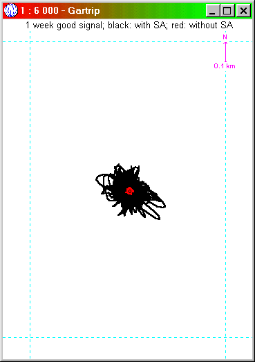
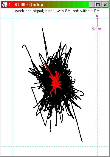
A long term fix with GPS and GARtrip Abstract The position of a fixed point was recorded for a whole week, in 30 seconds intervals. This should show the properties of the position error by GPS. The records are shown as scatter plots, histograms and with a list of characteristics. This test was made three times: firstly when the intentional degradation ("Selective Availability", SA) was effective. Secondly when the SA was gone.And thirdly with the EGNOS correction (this is the European version of WAAS). In addition, the effect of a partly shielded sky was compared with a full sky reception. To conclude the most important results: the removal of SA was a very big improvement of precision, about a factor of 10.But the addition of EGNOS has no significant effect at all. It seems that the present "test state" of EGNOS means that the differential correction is not yet effective. I will have to repeat this test when this test mode is finished.Do not rely on the "accuracy" indication of your receiver. An accuracy indication as low as 2 meters means only that the receiver believes it is so accurate. It does not mean that the position is really within 2 meters! Contents 1. How I made the records This document shows the results of a long term GPS measurement of a fixed position, in order to check the precision or, at least, the reproducibility of a GPS measurement. For this purpose, the position of a fixed point was recorded for a whole week, in 30 seconds intervals. This experiment shall show the precision of long-term measurements with averaging and the statistical distribution of error under different conditions. This check was made the first time was when the intentional degradation ("Selective Availability", SA) was effective, in fact this was in March and April 1999. Measurements on this condition are marked in black within this document. The position of a fixed point was recorded by a Garmin GPS12XL (Firmware 3.02) with external antenna GA27. The antenna was fixed directly below a roof window, 30° slanted eastwards. Besides the roof itself there was nothing obstructing the satellite reception. The track log memory of the Garmin receiver is not big enough, so it was substituted by the function "Actual position" within GARtrip. A deeper review was published by David L. Wilson; further references may be found at Joe and Jack. On 2-MAY-2000 the SA was cancelled. Then I repeated the whole investigation without SA, using the same equipment, in May 2000. The results without SA are in red colour. You will notice a very big improvement A further improvement in GPS precision should be due to WAAS, or EGNOS here in Europe. EGNOS is active since April 2003. So I made one more record, comparing the precision with/without EGNOS, end of April 2003. The results with EGNOS are shown in blue colour. This test was made with a Garmin Etrex Vista (Firmware 3.10). Unfortunately, the EGNOS satellite was not received at the antenna position of the previous tests but it was received well at another west side roof window. So I repeated the non-EGNOS test with the Vista receiver at this window first, to prove that the result is comparable to the previous result with the 12XL. This was compared with the EGNOS test then. You won't notice any significant improvement here. It appears that the present test mode of EGNOS means that it's useless at present, although the "D" indication of the satellite bars was there, and the "accuracy" indication of the receiver goes down to 2 meters at some times. But please see yourself. To investigate in the effect of signal quality, two more records were made at the same position. This time the antenna was mounted 60 centimeters below the window (50 x 80 centimeters). The roof itself is coated by aluminium. This worsens the reception of satellite signals gradually, to simulate a critical condition. Some times the receiver showed "poor coverage". The record was started after the receiver showed "3D" the first time. In this record there are big errors (757 meters maximum), which may persist for some minutes. This additional "bad signal" tests were made for the black and red condition (with SA and without SA) but not for the blue one (with EGNOS). After recording, a new waypoint
was created by averaging the whole track log,
using the suitable GARtrip function. Now this
new waypoint should be compared with an exact
reference point, but such was not available.
Therefore the absolute precision cannot be
checked, but the reproducibility can. For this
purpose the record was repeated at another
position, displaced by 7 meters. In this case,
the average of the record showed 8 meters
distance from the original position. The error
of one meter can be disregarded as GARtrip
rounds all distances to the nearest meter. 3. Scatter plots of the records Following scatter plots show the
GARtrip charts of both records, both with same
scale. The black center point marks the
calculated average position.
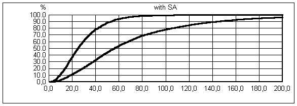
The following histograms show the probability that the GPS error is below a given value. For example, the black condition (with SA) is in 95 % of all measurements within 65 meters (good signal) or within 180 meters (bad signal). This compares to 57 meters by David L. Wilson. Left line: good signal (Record #1); right line: bad signal (Record #5).
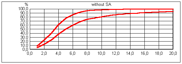
And here the same without SA; please note the different scale. Left line: good signal (Record #2); right line: bad signal (Record #6). The difference to the black chart is tremendous!
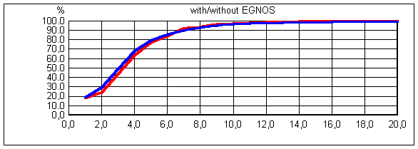
And now the comparison with/without EGNOS. Since the equipment was different than before (Vista receiver instead of 12XL, and other antenna location), a comparison record was made without EGNOS (Record #3). This line is shown in red. It should be equal to the left line of the histogram above, and in fact it is nearly the same, except for the result at 1 meter. The blue line shows the histogram with EGNOS active and, in fact, the difference seems negligible (Record #4).
Other differences are shown on the following table. Readers who wish to do their own calculations based on these records may ask the Author for the original records. Record 1: with SA
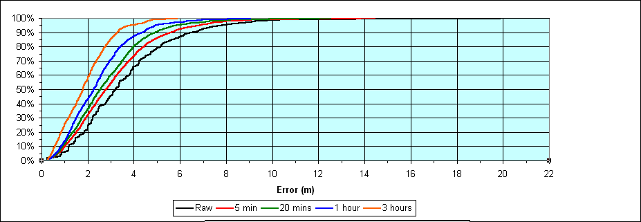
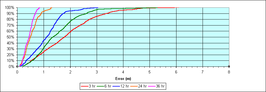
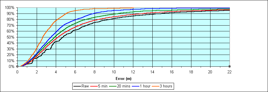
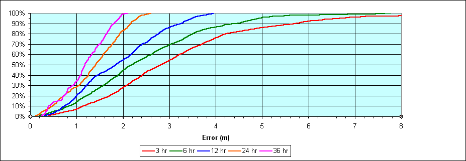
It appears that EGNOS improves the best possible precision a bit, but the worst case went worse with EGNOS. Of course the 80 m error could have happened by chance, and it would be better to make records #3 and #4 simultaneously, but I have only one set of receiver equipment. But I can say that errors bigger than 40 m happened at three different days during the record period. Officially, EGNOS will get operative middle of 2004. The present data transmitted by EGNOS are reported not to be consistent; only test data are sent. So it is recommended not to use it. 6. Averaging to improve precision Related to this investigation, it is interesting to see how the precision may be improved by averaging. Allen Oliver did such a calculation, based on the same sets of data. He averaged the positions for 5 minutes, up to 36 hours. The following diagrams show the improvements for "good signal" and "bad signal" conditions.
|